
Open access:
Nascimento, M.N., Aukes, T.F. & McMichael, C.N. (2024) Indigenous and colonial influences on Amazonian forests. Plants, People, Planet. DOI: 10.1002/ppp3.10515
May 20, 2024
Open access:
Nascimento, M.N., Aukes, T.F. & McMichael, C.N. (2024) Indigenous and colonial influences on Amazonian forests. Plants, People, Planet. DOI: 10.1002/ppp3.10515
June 29, 2020

Rahab Kinyanjui
USING PALAEOECOLOGICAL PROXIES TO DETERMINE ANTHROPOGENIC IMPACT ON VEGETATION DURING PRE-COLONIAL, COLONIAL AND POST-COLONIAL PERIOD IN KENYA’S HIGHLANDS-CASE STUDY ABERDARE RANGES
By Rahab KINYANJUI (National Museums of Kenya: Nairobi)
In spite of the challenges and uncertainties that the larger scientific community is currently facing, I am delighted and humbled to accept one of the British Ecological Society’s Ecologist in Africa research grant for 2020. The grant will support my historical ecology project whose main goal is to apply palaeoecological and archaeological proxies to investigate the extent of anthropogenic impacts on vegetation structure and composition of one of the Kenyan Central highlands before, during, and after the colonial period.
The Aberdare range forest provide an ideal setting for this study because they have been farmed by local populations since long before colonialism, and they were heavily impacted during colonial times because of their fertile soils. This pilot project aims to reveal the land-use and land-cover dynamics of the Aberdare range forest, and it is hoped that eventually similar studies will be undertaken in other parts of the Kenyan highland forests.
September 23, 2019

Mark Bush
The third of three guest blog posts by Prof. Mark Bush (Florida Institute of Technology). Click here to read Part 1. Click here to read Part 2.
Fast forward to 2019, the Aguarico is now lined by small homesteads interspersed with larger settlements, some laid out by the oil companies, and a couple of oil ports. I asked our guide how far the park was ahead of us, and he looked surprised and said “We are in it”. When we arrived at the Zancudo River there was a cell tower and a village of probably 30-50 houses on the junction with the Aguarico. Ten minutes downstream was a tourist lodge. What a difference! The frontier had expanded ~140 km down the Aguarico. One family with a shotgun eliminates all game larger than a marmoset within 5 km, and these homesteads were packed so tight it was unsurprising that we saw almost no wildlife.
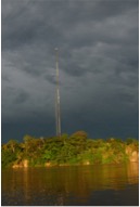
The cell tower at the village of Zancudococha. Photo: M. Bush.
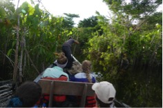
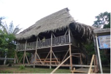
The next day we ventured onto Zancudococha. The Zancudo stream was still pretty, overhung by trees, and had no barriers to navigation. Three boats full of tourists passed us coming out of the lake, clearly having spent the night there. There were no logs to clear, and the path through the Montricardia marsh was two boats wide. There are only two patches of high, dry land on the edge of the lake. One was regularly used as a campsite and the other had a lodge built on it that was operated intermittently by the Zancudo community.
We saw no monkeys, let alone tapirs, this was an empty forest. But we weren’t there to be ecotourists, we were there to raise a sediment core. This time our questions were about the Pre-Columbian use of the lake. Was the lake occupied prior to European arrival? How much did people alter the forest? Was there a surge of forest regrowth following Conquest? Given these questions, the 1 m of sediment that we recovered with a Universal piston corer was all that we needed. One meter of mud from this system spans about 1500 years and that would provide us with the trajectory of use (or non-use) into the colonial period and its aftermath. Our mood in camp was happy, we had been successful in our intent. So, my message is you can’t go back to find what was there before, but that doesn’t mean that it will be a bad experience. Shifting baselines apply to nature in every setting, but they also apply to science as our questions and interests undergo inter-generational changes.
Mark Bush is a Professor of Biological Science at the Florida Institute of Technology, Melbourne, FL, USA.
