The 14th Mapping Ancient Africa seminar took place on Thursday 28th February 2024. The seminar was delivered by Mathias Vinnepand (Leibniz-Institute for Applied Geophysics Hannover, Germany) and presented recent advances in developing a chronology for the Lake Bosumtwi sediment record over the last c. 1 million years.
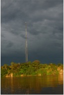
Fast forward to 2019, the Aguarico is now lined by small homesteads interspersed with larger settlements, some laid out by the oil companies, and a couple of oil ports. I asked our guide how far the park was ahead of us, and he looked surprised and said “We are in it”. When we arrived at the Zancudo River there was a cell tower and a village of probably 30-50 houses on the junction with the Aguarico. Ten minutes downstream was a tourist lodge. What a difference! The frontier had expanded ~140 km down the Aguarico. One family with a shotgun eliminates all game larger than a marmoset within 5 km, and these homesteads were packed so tight it was unsurprising that we saw almost no wildlife.
The cell tower at the village of Zancudococha. Photo: M. Bush.
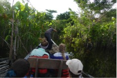
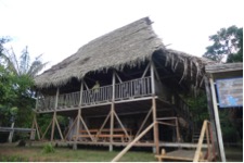
The next day we ventured onto Zancudococha. The Zancudo stream was still pretty, overhung by trees, and had no barriers to navigation. Three boats full of tourists passed us coming out of the lake, clearly having spent the night there. There were no logs to clear, and the path through the Montricardia marsh was two boats wide. There are only two patches of high, dry land on the edge of the lake. One was regularly used as a campsite and the other had a lodge built on it that was operated intermittently by the Zancudo community.
We saw no monkeys, let alone tapirs, this was an empty forest. But we weren’t there to be ecotourists, we were there to raise a sediment core. This time our questions were about the Pre-Columbian use of the lake. Was the lake occupied prior to European arrival? How much did people alter the forest? Was there a surge of forest regrowth following Conquest? Given these questions, the 1 m of sediment that we recovered with a Universal piston corer was all that we needed. One meter of mud from this system spans about 1500 years and that would provide us with the trajectory of use (or non-use) into the colonial period and its aftermath. Our mood in camp was happy, we had been successful in our intent. So, my message is you can’t go back to find what was there before, but that doesn’t mean that it will be a bad experience. Shifting baselines apply to nature in every setting, but they also apply to science as our questions and interests undergo inter-generational changes.
A broad path through the marsh at Zancudococha. Photo M. Bush
The lodge at Zancudococha. Photo: M. Bush.
Mark Bush is a Professor of Biological Science at the Florida Institute of Technology, Melbourne, FL, USA.
Dobrochna wondering what kind of pollen and phytoliths are hidden it that piece of dirt (Krakenven, 2018)
Looking at a time capsule from Twente
By Dobrochna Delsen (currently studying for BSc Biology at the University of Amsterdam)
An unusual early morning.
It is 8:15. My train arrives at Science Park. After a ten-minute walk accompanied by other students I arrive at the university. After a short contemplation about whether I should take the elevator, I decide to take the stairs. The stairs are a bit exhausting, especially since the microscope room is at the top floor, but it gives me the necessary ‘exercise’ for the day. As I walk to the room at the end of the corridor I can see that the coat rack is still empty, except of the one lab coat that hangs there since the day my bachelors project started. I take out my student card and hold it against the door handle. The sound of the unlocking door gives me feeling of satisfaction and power. I step into the empty room with a feeling of superiority and go to my microscope where I will sit for the rest of the day.
Over the last two weeks I have been giving my lectures at the VU Amsterdam “Scientific Methods in Archaeology” bachelor program. In my lectures we think about how to detect past environmental change with particular reference to tracking past human activities. As part of our exploration of past human-environment-climate interactions each student is asked to choose a scientific article, summerise it, and we then discuss it in class. The three papers sected this year covered the Neolithic of the Netherlands (Weijdema et al., 2011), a overview of Mediterranean and north African cultural adaptations to drough events during the Holocene (Mercuri et al., 2011), and an exploration of the role of humans in mega-faunal extinctions in South America (Villavicencio et al., 2015). All papers provided interesting points of discussion and an opportunity to think about different aspects of how we investigate past environmental and societal change.
Hello all! You might have been wondering if I died in the middle of Amazonian nowhere, since I haven’t come back to writing a blog after we left for fieldwork in July. Given we were in an Amazonian region full of venomous snakes that could have been the case, but the good news is I just didn’t get around writing it because I got carried away by the findings of my project! We actually had a very successful field trip – apart from some minor issues like the lake swallowing equipment, sinking waist-high into the mud each step of our 7 hour long ‘trail’ to the lakes, and almost not getting my precious samples through airport security.
Matthews-Bird, F., Brooks, S.J., Gosling, W.D., Gulliver, P., Mothes, P. & Montoya, E. (2017) Aquatic community response to volcanic eruptions on the Ecuadorian Andean flank: Evidence from the palaeoecological record. Journal of Paleolimnology 58: 437-453. DOI: 10.1007/s10933-017-0001-0
Bush, M.B., Restrepo, A. and Collins, A.F. (2014) Galápagos history, restoration, and a shifted baseline. Restoration Ecology, 22, 3, 296-298.
Summary (Nick): A concise and pithy look at how a robust long-term ecological system can be transformed rapidly by human impact. The paper demonstrates how the fossil pollen record is fundamental if a near-natural vegetation state is to be restored to the Galápagos islands, to avoid restoration to a shifted baseline.
Frazer Bird and William Gosling talk about how to conduct palaeoecological research in the tropics for NERC’s Planet Earth pod-cast. Click here to here to listen to the conversation.
For other similar stories online visit the Planet Earth website.
Montoya, E. (2011) Paleocology of the southern Gran Sabana (SE Venezuela) since the Late Glacial to the present. PhD Thesis, Department of Animal Biology, Plant Biology and Ecology, Unitersitat Autonoma de Barcelona.
EM Venezuela (2007)
Abstract:
This thesis is aimed to study the paleoecology of the southern Gran Sabana region (GS; SE Venezuela) since the Late Glacial to the present. This region is characterized nowadays by the occurrence of large extent of savannas in a climate suitable for rainforests. For this purpose, three sequences (two from peat bogs and one from lake sediments) have been analyzed for pollen and spores, non-pollen palynomorphs (NPP), and microscopic charcoal particles. Among the sequences analyzed, two of them are located currently within treeless savannas (Lakes Chonita and Encantada); whereas the third one is placed in the boundary between GS savannas and Amazon forests (El Paují). The Late Glacial interval of Lake Chonita was characterized by a shrubland that was replaced by a treeless savanna at the end of Younger Dryas (YD) and the onset of the Holocene, linked to the occurrence of regional fires since ca. 12.4 cal kyr BP. The beginning of local fires was dated synchronous with the vegetation replacement, ca. 11.7 cal kyr BP. A similar shrubland, though not identical, is located nowadays around 200 m elevation above the lake, so the replacement by surrounding savannas was interpreted as a probably upward displacement of the former vegetation and an increase in average temperatures of approximately 0.7 ‐1.5ºC. This section represents the oldest interval analyzed for GS so far, and the presence of fires during the Late Pleistocene is among the oldest fire records documented for northern South America. The peat bog records of Lake Encantada and El Paují showed the main vegetation trends of the last 8 cal kyr BP, which were characterized by the continuous occurrence of regional fires. In Lake Encantada, the presence of treeless savannas was reported during the whole interval analyzed as the dominant vegetation type, despite variations in forest abundance and composition taxa of the community also occurred. The vegetation changes in this record were interpreted as mainly due to climatic shifts until the Late Holocene. At El Paují, the occurrence of forests and savanna/forest mosaics was reported during the same interval, and fire was postulated to have been the major driver of the vegetation shifts. In this sequence, a treeless savanna was not recorded as the dominant vegetation of the landscape until the last millennia, and the presence of two different indigenous cultures was postulated as responsible of the shifts in fire regime registered, with an interval of human land abandonment between them. This interval was characterized by the cessation of fires, and the establishment of a secondary dry forest. The Late Holocene was characterized, in the three sequences studied, by a sudden increase of fires, which likely favored the expansion of savannas and the establishment of the present GS landscape.
The join interpretation of the records presented in this thesis, together with previous analyses in the region, highlighted some key aspects for understanding the main trends of GS landscape and vegetation, e.g., the appearance and establishment of morichales (Mauritia palm stands typical of current southern GS landscapes) has been restricted to the last two millennia, synchronous with the increase in fire incidence. Moreover, it has been possible to gather empirical evidence for testing some previous hypothesis regarding GS. For example, the proposal of an extended aridity prior the Holocene has been rejected, whereas the hypothesis about the postglacial expansion of morichales has been supported. In this sense, with all the available information to date, some suggestions have been proposed: (i) Climate and fire have been the major forcing factors operating in the GS; (ii) During the Late Glacial and the beginning of the Early Holocene, the landscape of southern GS was likely formed by a mosaic of forests, shrubs, and savannas, without the current supremacy of the last vegetation type, which only established during the last 2 cal kyr BP onwards; (iii) Some general climatic trends have been inferred for the study area, as for example an increase in average temperatures around the Late Glacial/Early Holocene transition, a dry interval from 8 to 5 cal kyr BP, and a wetter phase during the Mid-Holocene centered around 4 cal kyr BP; (iv) The establishment of Mauritia in the region has been likely driven by a synergism between biogeographical, climatic and anthropogenic factors, as well as the likely pyrophilous nature of this palm given its synchronous appearance with the increase of fires; (v) The settlement of the modern indigenous culture (Pemón) occurred at least since around ca. 2000 cal yr BP onwards, 1500 yr earlier than previously thought, but previous human presence in the region has been also documented; and (vi) The fire activity observed in the long-term has caused a huge impact on GS landscape.